
![]()


Parks and Memorials of the State of Illinois
Compiled by C. M. Service, Springfield, ILL: Schnepp & Barnes, Printers, 1920.
|
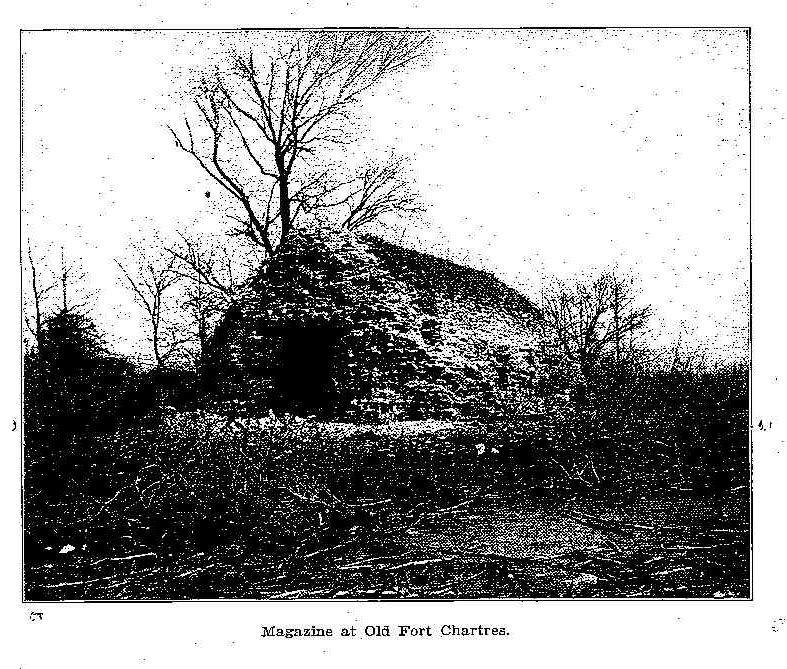
Fort Chartres is located in Randolph County, about three miles north of the village of Prairie
du Roches. Early Illinois history centers about Fort Chartres, the hub of French influence in
the central west for almost half a century before it was wrested from them in 1865 by the
British. The first fort, constructed in an alluvial bottom, three-fourths of a mile from the
Mississippi River, in the northwest corner of Randolph County; was built of wood with a stockade
of timber. The second fort, constructed of limestone quarried from the river bluffs, was located
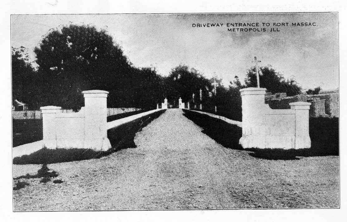
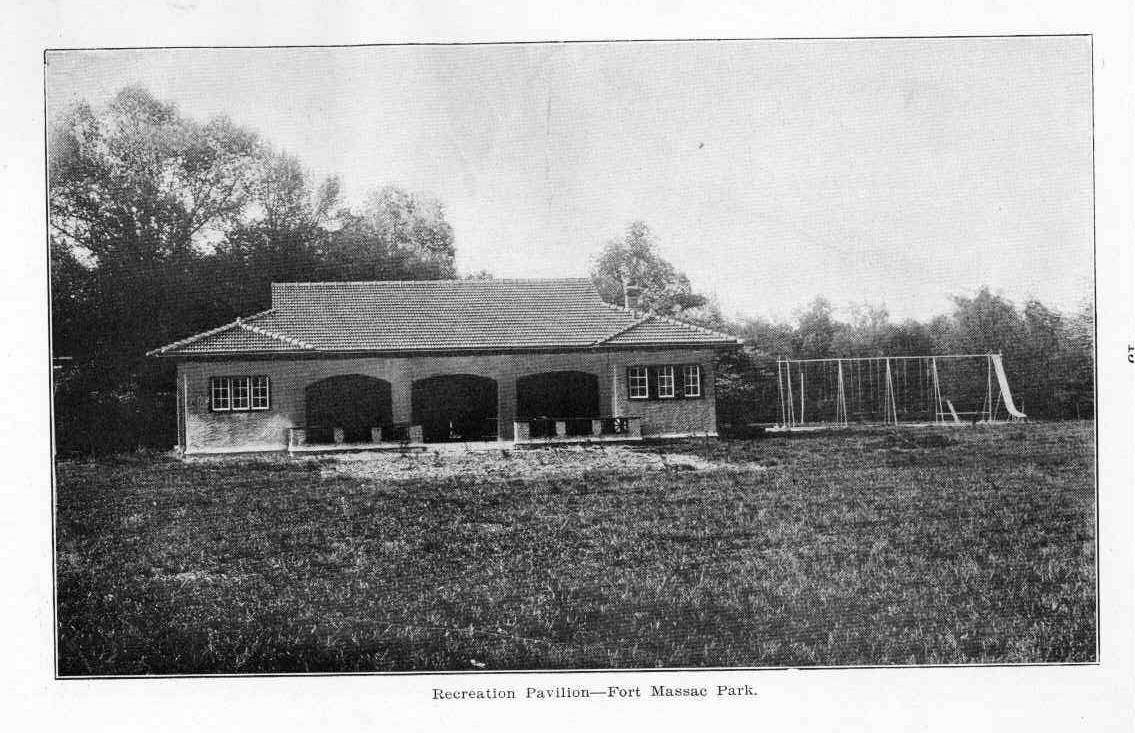
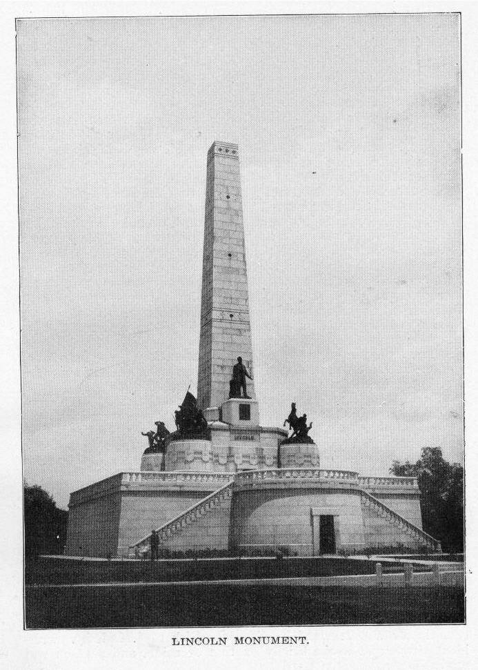
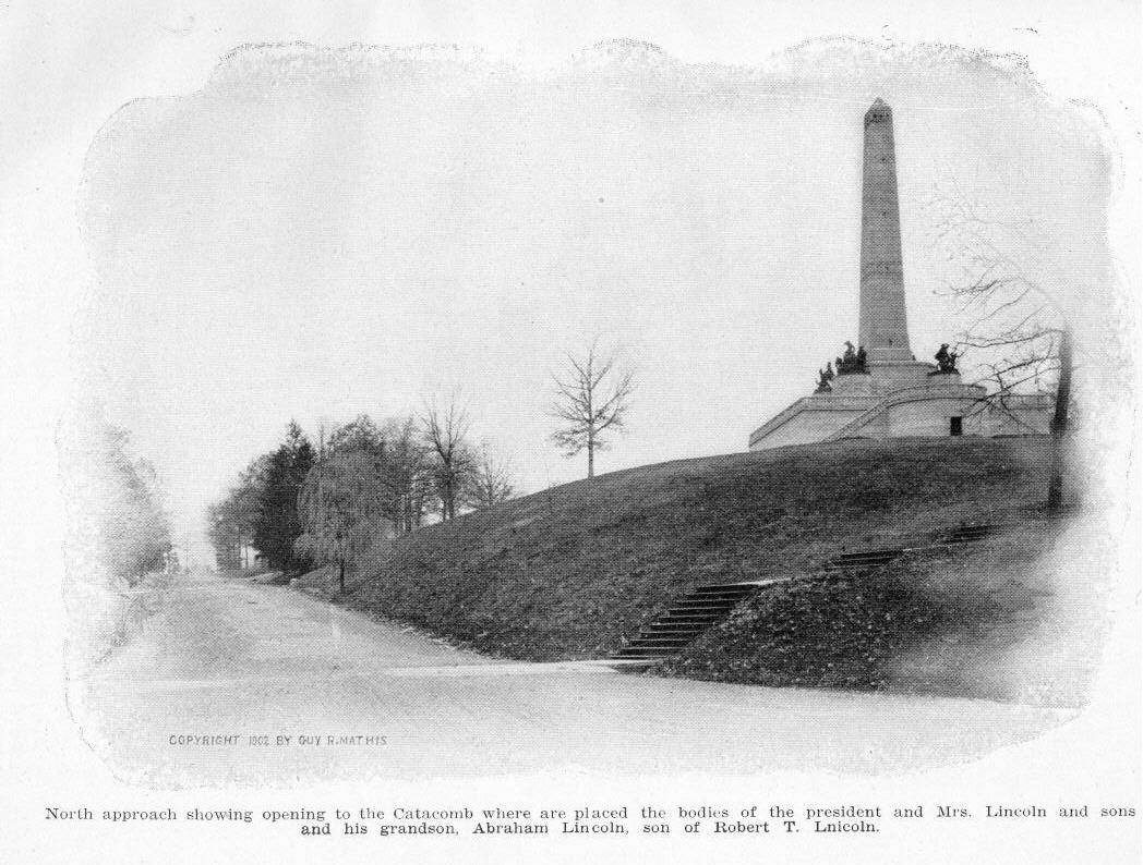
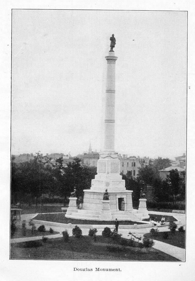
a mile above the old fort and half a mile from the river. Fort de Chartres, named for the Duke de Chartres, son of the regent of France, was built to give protection to the Company of the West or Mississippi Company, organized in 1717 and holding sway for fourteen years. A village grew up rapidly between the fort and the river and Jesuit missionaries established the church of St. Anne. Later Phillippe Francis de Renault, director general of mining operations of the Company of the West, brought over two hundred French miners and five hundred Guinea slaves, introducing negro slavery into what was later Illinois, although Indian slavery was not uncommon. In 1831 the India Company, successors to the Company of the West, retroceded possession to the crown and Louis XV proclaimed jurisdiction. Louisiana was separated from Canada and Illinois was organized as a dependency commanded by Captain Pierre D'Artagnette, later burned to death by the Indians. War was declared between France and England in 1744 and the colonies became embroiled. It was in 1765 that the French Fleur de Lis was drawn down and the Red Cross of St. George unfurled. In 1772 a freshet washed away the bastion of the fort and the garrisons deserted it, going to Kaskaskia, which in later years fell before George Rogers Clark and his valiant men. After 1772 the fort never was occupied except by Indians. In 1778 Congress reserved from entry or sale a tract of land a mile square, including Fort Chartres and its buildings. Source: Parks & Memorials of the State of Illinois, Under the Supervision of the Department of Public Works and Buildings, Compiled by C. M. Service. Printed by the authority of the State of Illinois. Springfield: Schnepp & Barnes, Printers. 1920. More history of Fort Chartres Fort Massac (photo 1, photo 2) Fort Massac is located in Massac county, on the Ohio river, near the present city of Metropolis.It is historically significant. It offered the opening wedge by which George Rogers Clark entered and conquered from the British the expansive northwest territory composing the present states of Illinois, Indiana, Ohio, Wisconsin and parts of Michigan and Minnesota. This intrepid explorer navigated down the Ohio to Fort Massac, captured the garrison and then proceeded overland one hundred and twenty miles with a handful of hardy woodsmen soldiers from Virginia to Kaskaskia and Vincennes, wresting from the English those posts and hoisted the American flag, marking the end of foreign dominance. Historical accounts have it that the site was first visited by De Soto, in the year 1542 when it was used as a temporary fortress against the Indians. Aaron Burr also stopped at this point in 1805, while en route to the south to establish an empire which was to have absorbed the American Republic, with Burr at its head. The fort itself was built by Captain Charles Phillips Aubrey, sent into the Illinois country in 1756 from New Orleans, to care for French interests against encroachments of the British. Leaving Fort Chartres on May 10, 1757, Aubrey reached Massac the same year and drove the first stake on Ascension Day: hence the stronghold first bore the name Fort Ascension. The fort was captured in 1765 by the English, who held it thirteen years until its fall before George Rogers Clark. In 1794, the old block house and palisades were rebuilt by order of President George Washington as a protection for American settlers who began pushing westward in great numbers. The origin of the name, Fort Massac, has not been determined. A legend recounts a massacre by Indians during French occupancy and the taking of the name Fort Massacre, which was later abbreviated to Fort Massac. The Indians, so the story reads, appeared on what is now the Kentucky side of the river, garbed in bear skins and crawling on their hands and knees. Soldiers of the garrison quickly crossed the river to make a killing. In their absence, a party of Indians fell upon the unprotected settlement, murdering every inhabitant and setting fire to the buildings. Until its purchase by the State in 1903, through the instrumentality of the Daughters of the American Revolution, the site of Fort Massac bore few marks of its former importance. Only ruins of earthworks were there to show the shape of the blockhouses. The State has done everything possible to preserve the historic spot without marring its native beauty and without destroying the reminders of the past. The park has been landscape-gardened, with roads and walks carefully laid out, and a custodian's cottage and recreation hall for the use of visitors have been built. To Clark and his brave men there has been erected a monument. From the top of Fort Massac, recognized as a natural fortress, smoke from the city of Paducah can be seen. Source: Parks & Memorials of the State of Illinois, Under the Supervision of the Department of Public Works and Buildings, Compiled by C. M. Service. Printed by the authority of the State of Illinois. Springfield: Schnepp & Barnes, Printers. 1920. Lincoln Monument Lincoln Monument and Lincoln Memorial Hall are 1ocated in Oak Ridge Cemetery, Springfield, Illinois. This shrine is visited annually by thousands of persons of this and other countries.The body of Abraham Lincoln was deposited in the receiving vault at Oak Ridge Cemetery May 4, 1865. Upon the 11th of May, 1865, the National Lincoln Monument Association was formed, its object being to construct a monument to the memory of Abraham Lincoln in the City of Springfield, Illinois. The names of the gentlemen comprising the Lincoln Monument Association in 1865 (now deceased) were as follows: Gov. Richard Oglesby, Sharon Tyndale, Orlin H. Miner, Thomas J. Dennis, John T. Stuart, Newton Bateman, Jesse K. DuBois, S. H. Treat, James C. Conkling, O. M. Hatch, John Williams, S. H. Melvin, Jacob Bunn, James H. Beveridge, David L. Phillips. The temporary vault was built and the body of President Lincoln removed from the receiving vault of the cemetery on December 21, 1865. The body was placed in the crypt of the monument September 19, 1871, and was placed in the sarcophagus in the center of the catacomb October 9, 1874. Owing to the instability of the earth under its foundation and its unequal settling the structure had begun to show signs of disintegration, necessitating taking it down and rebuilding it from the foundation. The work has begun by Col. J. S. Culver in November, 1899, and finished June 1, 1901. A cemented vault was made beneath the floor of the catacomb directly underneath the sarcophagus and in this vault the body of President Lincoln was placed September 26, 1901, where it will probably remain undisturbed for ever. The monument is built of brick and Quincy granite, the latter material only appearing in view. It consists of a square base 72 1/2 feet on each side and 15 feet, 10 inches high. At the north side of the base is a semi-circular projection, the interior of which has a radius of 12 feet. It is the vestibule of the catacomb, and gives access to view the crypts in which are placed the bodies of Mr. Lincoln's wife and sons and his grandson, Abraham Lincoln, son of Hon. Robert T. Lincoln. On the south side of the base is another semi-circular projection of the same size, but this is continued into the base so as to produce a room of elliptical shape, which is called Memorial Hall. Thus the base measures, including these two projections, 119 1/2 feet from north to south and 72 1/2 feet from east to west. In the angles formed by the addition of these two projections are handsome flights of stone steps, two on each end. These steps are projected by granite balustrades, which extend completely around the top of the base, which forms a terrace. From the plane of this terrace rises the obelisk, or die, which is 28 feet 4 inches high from the ground, and tapered to 11 feet square at the top. At the angles of this die are four pedestals of 11 feet diameter, rising 12 1/2 feet above the plane of the terrace. This obelisk, including the area occupied by the pedestals, is 41 feet square, while from the obelisk rises the shaft, tapering to 8 feet square at the summit. Upon the four pedestals stand the four bronze groups, representing the four arms of the service - Infantry, Cavalry, Artillery and Navy. Passing around the whole obelisk and pedestal is a band or chain of shields, each representing a state, the name of which is carved upon it. At the south side of the obelisk is a square pedestal, 7 feet high, supporting the statue of Lincoln, the pedestal being ornamented with the coat of arms of the United States. This coat of arms, in the position it occupies on the monument, is intended to typify the Constitution of the United States. Mr. Lincoln's statue on the pedestal above it makes the whole an illustration of his position at the outbreak of the rebellion. He took his stand on the Constitution as his authority for using the Cavalry, Artillery and Navy - to hold together the states which are represented still lower on the monument by a cordon of tablets linking them together in a perpetual bond of union. The money used in the original construction of this handsome monument came from the people by voluntary contributions. The first entry made by the treasurer of the association was May 8, 1865, and was from Isaac Reed, of New York, $100. Then came contributions from Sunday schools, lodges, Army associations, individuals and states. The Seventy-Third Regiment, United States colored troops, at New Orleans, contributed $1,437, a greater amount than was given by any other individual or organization except the State of Illinois. Many pages of the record are filled with the contributions from the Sunday schools of the land. Of the 5,145 entries, 1,697 are from Sunday schools. The largest part of the money was contributed in 1865, but it continued to come to the treasurer from all parts of the country until 1871. About $8,000 was contributed by the colored soldiers of the United States Army. Only three other states made appropriations for this fund - Illinois, $50,000; Missouri, $1,000, and Nevada, $500. The monument was dedicated October 15, 1874, the occasion being signalized by a tremendous outpouring of the people. The oration commemorative of the life and public services of the great emancipator was delivered by Governor Richard J. Oglesby. President Grant also spoke briefly on that occasion, and a poem was read by James Judson Lord. The monument was built after the accepted designs of Larkin G. Mead, of Florence, Italy, and stands upon an eminence in Oak Ridge Cemetery, occupying about nine acres of ground. Ground was broken on the site September 10, 1869, in the presence of 3,000 persons. The capstone was placed in position on May 22, 1871. In July, 1871, citizens of Chicago, through Hon. J. Young Scammon, contributed $13,700 to pay for the Infantry group of statuary. In the city of New York, under the leadership of Gov. E. D. Morgan, 137 gentlemen subscribed and paid $100 each, amounting to $13,700 for the Naval group. Of the four groups of statuary, the Naval group was the first completed. This group represents a scene on the deck of a gunboat. The mortar is poised ready for action; the gunner has rolled up a shell ready for firing; the boy, or powder monkey, climbs to the highest point and is peering into the distance; the officer in command is about to examine the situation through the telescope. The Infantry group was the next to reach Springfield. Both these groups were placed in position on the monument in September, 1877. The Infantry group represents an officer, a private soldier and a drummer, with arms and accoutrements, marching in expectation of battle. The officer in command raises the flag with one hand; pointing to the enemy with the other, orders a charge. The private with the musket, as the representative of the whole line, is in the act of executing the charge. The drummer boy has become excited, lost his cap, thrown away his haversack and drawn a revolver to take part in the conflict. The Artillery group represents a piece of artillery in battle. The enemy has succeeded in directing a shot so well as to dismount the gun. The officer in command mounts his disabled piece and with drawn saber fronts the enemy. The youthful soldier, with uplifted hands, is horrified at the havoc around him. The wounded and prostrate soldier wears a look of intense agony. The Cavalry group, consisting of two human figures and a horse, represents a battle scene. The horse, from whose back the rider has just been thrown, is frantically rearing. The wounded and dying trumpeter, supported by a comrade, is bravely facing death. Each of these groups cost $13,700. The statue of Mr. Lincoln stands on a pedestal projecting from the south side of the obelisk. This is the central figure in the group, or series of groups. As we gaze upon this heroic figure the mute lips seem again to speak in the memorable words that are now immortal. We hear again the ringing sentences spoken in 1859 of the slave power: Broken by it, I too, may be; bow to it, I never will. * * * If ever I feel the soul within me elevate and expand to those dimensions not wholly unworthy of its Almighty Architect, it is when I contemplate the cause of my country deserted by all the world beside, and I, standing up boldly and alone, hurling defiance at her victorious oppressors. Here, without contemplating consequences, before high Heaven and in the face of the world. I swear eternal fidelity to the just cause, as I deem it, of the land of my life, my liberty and my love. From the day of its dedication, October 15, 1874, until July 9, 1895, the Lincoln Monument remained in the control of the National Lincoln Monument Association. In 1874, after its dedication, John Carroll Power was made custodian, and continued in that position until his death in January, 1894. A sketch of the Lincoln Monument could not, in fairness, be written without paying a tribute to his faithfulness, zeal and love. He revered the nation's hero and gave to his last resting place the tenderest and most assiduous care. Much that is of interest in the history of this first decade of the existence of the monument has been written by his untiring pen that would otherwise have been lost. After the attempt was made to steal the body of President Lincoln, Mr. Power summoned to his aid, in 1880, eight gentlemen, residents of Springfield, who organized as the "Lincoln Guard of Honor." They were J. Carroll Power, deceased; Jasper N. Reece, deceased; Gustavus S. Dana, deceased; James F. McNeill; Joseph P. Lindley; Edward S. Johnson; Horace Chapin, deceased; Noble B. Wiggins, deceased, and Clinton L. Conkling. Their object was to guard the precious dust of Abraham Lincoln from vandal hands and to conduct, upon the anniversaries of his birth and death, suitable memorial exercises. During these years an admittance fee of twenty-five cents was required of all visitors to the monument, and this small fee constituted a fund by which the custodian was paid and the necessary expenses of the care of the grounds defrayed. In the winter of 1894, in response to a demand voiced almost universally by the press and the people of Illinois, the General Assembly made provision for the transfer of the National Lincoln Monument and grounds to the permanent care and custody of the State. The new law put the monument into the charge of a board of control, consisting of the Governor of the State, the State Superintendent of Public Instruction and the State Treasurer. July 9, 1895, Hon. Richard J. Oglesby, the President, the only surviving member of the original Lincoln Monument Association, turned over to the State, as represented by its chief executive, Governor Altgeld, the deeds and papers relating to the monument and grounds. The governor received the trust on behalf of the State, pledging its faithfulness to the duty of guarding and caring for the last resting place of the illustrious dead. The commission appointed as custodian Edward W. Johnson, major of the veteran Seventh Illinois Infantry and a member of the Lincoln Guard of Honor. The admittance fee is a thing of the past and "To the Mecca of the people let all of the people come, bringing garlands of flowers, carrying away lessons of life. There is no shrine more worthy of a devotee, no academy of the porch or grove where is taught so simply and so grandly the principles of greatness. Strew flowers, but bear away the imprint of his life, the flower of manliness and the wreath of honor." Memorial Hall Within Memorial Hall at the south end of the Monument the visitor will find a number of interesting articles which were used by Mr. Lincoln personally, or which are in some way associated with his memory.Among these is a block of rough-hewn brown stone bearing an inscription in Latin, which was sent to Lincoln after his election for the second time as President of the United States, by a group of patriotic citizens of Rome. An interesting story is connected with this stone. In the early days of Roman history, about five hundred and seventy-eight years before the birth of Christ, there ascended to the throne of Rome a wise and good king called Servius Tullius. His origin is more or less mythological but it is supposed that one or both of his parents were slaves. This king ruled with justice and benevolence and his earnest efforts were directed toward the amelioration of right to make a slave of his impecunious debtor and even succeeded in establishing a constitution which gave these poor wretches political independence. These acts of the king aroused the jealousy and hatred of the nobility and they determined upon his destruction. Tullius had two daughters, both married. One called Tullia, of evil memory, killed her own husband and espoused Lucius Tarquinius, the husband of her gentler sister who had been murdered by this same Tarquinius. Tarquinius and Tullia at the head of the mob seized the throne of Tullius, and that unfortunate monarch while walking unsuspectingly through the streets of his city, was struck down and assassinated by a follower of his wicked son-in-law. His body was left in the street where it fell and his infamous daughter Tullia drove her chariot over it in triumph. One of the earliest acts of Servius Tullius had been to add to his capital three of the neigboring hills, thus making Rome the City of Seven Hills. Around the boundary of the new city he built a wall of stone which encircled Rome for seven hundred years and was always known as the wall of Servius Tullius. During the centuries of oppression and tyranny which make up the history of Rome, there has always existed a small minority who have loved liberty and justice, and these few kept alive from generation to generation the memory of Servius Tullius. Looking on from generation to generation the memory of Servius Tullius. Looking on from afar at the four years' struggle in the United States, in which freedom for the down-trodden was eventually gained, the patriots of Rome saw in President Lincoln, whose great heart and steadfast courage had liberated four million slaves, an embodiment of their ideal of the ancient king whose memory they so lovingly cherished. Therefore, after his second election as President, they took from the Wall of Servius Tullius, where it had reposed for more than two thousand years, a fragment stone. On it they engraved in Latin an inscription which, translated, reads: "TO ABRAHAM LINCOLN, PRESIDENT FOR THE SECOND TIME OF THE AMERICAN REPUBLIC, CITIZENS OF ROME PRESENT THIS STONE, FROM THE WALL OF SERVIUS TULLIUS, BY WHICH THE MEMORY OF EACH OF THESE ASSERTORS OF LIBERTY MAY BE ASSOCIATED. 1865." This stone they sent to President Lincoln. In all probability it reached him before his death and with his characteristic modesty he forebore to mention it. It was eventually discovered in the basement of the White House. By an act of Congress, 1870, introduced by the Senator Shelby M. Cullom, of Illinois, the stone was transferred to Springfield to be placed in the National Lincoln Monument then in process of erection.The stone is of conglomerate sandstone pronounced by a geologist of Illinois to be in all probability artificial. It is 27 1/2 inches long, 19 inches wide and 8 3/4 inches thick. The upper edge and ends are rough as broken by a hammer; the lower edge and the side which bears the inscription are dressed true. The stone has no intrinsic beauty, but because of its associations, it will always be an object of interest to all lovers of liberty. Many things used by Lincoln in his lifetime are preserved in Memorial Hall. Here are his surveying instruments, the compass, chain and Jacob staff and the worn old black leather saddlebags in which he carried implements and papers when as a young man, he went surveying in Sangamon County. There is a soap dish which was in his bedroom and curtain fixtures, tassel and cord from his Springfield home. There are two small black cane-seated chairs which are of his first set of parlor furniture; a big ink-stained deal table and a plain wooden rocker both of which were in his law office in Springfield at the time he was elected President. In a glass frame is a faded piece of white silk with a pattern of red flowers. Deeper than the red of the flowers are dark stains of blood. This bit of silk is from the gown of the actress, Miss Laura Keene, who acted the leading role in "Our American Cousin" at Ford's Theater in Washington, on the night of Lincoln's assassination. When the murderer's shot rang out and the audience sat stunned and horror stricken, Miss Keene stepped from the stage into the President's box and took his wounded head upon her knees. She herself, one year later brought the piece of blood-stained silk to Springfield and presented it to the National Lincoln Monument. Among the number of Lincoln's personal letters which may be seen at the Monument, is a copy of one of his own hand, written to a little girl in Westchester County, New York, which shows his never failing courtesy and kindness. This little girl of thirteen, Miss Grace Bedell, wrote to Mr. Lincoln during his first campaign for President, telling him she thought he would look better if he would wear whiskers. In the midst of all the turmoil and excitement of the political battle he had time to stop and write a personal reply to a child. In all seriousness he told her that as he had never worn whiskers, he feared it might be considered a piece of "silly affectation" if he were to begin to cultivate them. Not long afterwards, however, he did raise the beard which he wore until his death. He never forgot his little friend and on a later occasion when he made a hurried trip through the town delivering campaign speeches, he called for the child and taking her hand, he talked with her and told her that she might observe, he had decided to follow her advice. There are many photographs of scenes made forever dear to the American people because of their association with the life of Lincoln; his birthplace in Kentucky; the cabin in which his parents were married; the little home in Indiana where his mother died; the wooden shack in which he kept post office and store in New Salem, Sangamon County, Illinois; the old Rutledge mill where he probably met his first love, Ann Rutledge; his law office in Springfield; the fine old home in which he married Mrs. Lincoln; the tavern where they spent their honeymoon and many other photographs. An almost life-size portrait of Lincoln was presented to the Monument by Thomas J. Lincoln, a cousin of the President. This picture was painted by Dr. E. E. Fuller, of Keokuk, Iowa, and was awarded as a prize to the Fountain Green Wide Awakes, a political organization which took active part in the campaign of 1860. The Wide Awakes carried the picture in their parades and kept it until after Mr. Lincoln's second inauguration as President. They then presented it to Thomas J. Lincoln, of Fountain Green, who fulfilled a long cherished desire when, on his eighty-third birthday he carried it himself to Lincoln's tomb in 1906. In Memorial Hall may be seen an immense volume containing 930 quarto pages. It is made up of copies of the notes and resolutions of sympathy which flooded the White House after the assassination of Lincoln. By a joint resolution of both Houses of Congress, this volume was published in 1867, in order to preserve these expressions of sympathy which were sent from all parts of the world, written in not less than twenty-five languages. Legislative bodies, corporations, voluntary societies, public assembles called together for the occasion and private individuals, one and all expressed their horror at the crime and their warm sympathy with the bereaved family of the President and the American people. A number of the original documents sent to Mrs. Lincoln and the United States Government, after Lincoln's death, were forwarded by Robert T. Lincoln, son of the President, to John T. Stuart, of Springfield, in 1871, and these now hang framed on the walls of Memorial Hall. Most of them are on heavy vellum or parchment and are beautifully embossed. Old Salem Park The newest accession in park properties is Old Salem, the former home of Abraham Lincoln, located on the Sangamon River, near Petersburg.A campaign to create interest in making Old Salem a State park was undertaken by the Old Salem Lincoln League and the cooperation of prominent persons all over the world was enlisted. Governor Frank O. Lowden, David Lloyd George, premier of England, and President Woodrow Wilson were among those who subscribed toward the initial work and are charter members of the League. Through the instrumentality of the Old Salem Lincoln League, the title to the tract of some sixty acres was made over to the State by William Randolph Hearst free of cost in the year 1919. Abraham Lincoln reached New Salem in 1831 after becoming acquainted with many of the citizens of the village as the result of a barge trip down the Sangamon River. The scow on which he was traveling with a cargo of merchandise stuck on the Old Salem dam and forced a delay. It is said, that on this occasion, Lincoln saw for the first time Ann Rutledge, daughter of the tavern keeper, with whom he fell in love. It was at Old Salem that Lincoln kept store, practised surveying, gained fame for whipping the Clary gang, was made a captain in the Black Hawk War, studied law and was elected to the legislature, then sitting at Vandalia. The historic village was founded on an eminence three years before Lincoln's advent by John M. Cameron and James Rutledge. It was here that the name "Honest Abe" is said to have attached itself to Lincoln because of his scrupulous honesty in dealing with customers while keeping store. It is related that once when he had made incorrect change, he walked three miles after quitting time to make reparation. Old Salem was at the height of its prosperity when Lincoln arrived and its decline set in soon after his departure seven years later. Research work of the Old Salem Lincoln League brought to view the depressions made along the forgotten streets by the foundations of the then existing buildings, which it is the intention of the Department of Public Works and Buildings to restore. A beginning on this program was made, before the State obtained title, by the League members who spent days of personal service with pick, shovel and hammer. In addition to the foundations, the discoveries include the almost obliterated road leading out of the village to Springfield and the path from Offut's store, where Lincoln clerked, down to the grist mill where he was wont to officiate. Among the buildings already restored or to be restored are: Rutledge Inn, where Lincoln boarded and courted Ann Rutledge; Berry and Lincoln store; Hill and McNamara store; Herndon's store; Offut's store; Martin Waddell's hat making establishment; Minta Graham school; Bale's carding machine house; Joshua Miller's blacksmith shop; Onstott's cooper shop, the residence of Dr. Allen and a number of others whose owners have been identified. Plans for a custodian's cottage and relic house have just been completed and work on these will shortly be started. These buildings will be constructed in harmony with the types of those days. The relic house will be of fire proof construction and will house the relics, mementos, etc., of Lincoln and Old Salem, a great many of which are now on hand and many more have been promised. Later the program of the State includes the resoration of the old grist mill. The first capitol building of the State of Illinois was built on its present site in the city of Vandalia in 1822 and now stands in the midst of a park some 320 feet square, filled with a large growth of forest trees. It is a plain two-story building, constructed of brick, with heavy walls built to stand the waste of time and is now a sturdy, old-fashioned building, encrusted with the rust of antiquity. It, with the plot of ground on which it stands, was donated by the State of Illinois to the county of Fayette in 1839. The building is in a good state of preservation and is as originally constructed with the exception that the large brick columns that supported the north and south porches were taken down in 1899 and replaced by the present iron columns and structures. The interior of the building is as well preserved and cared for as the exterior. The lower half of the building is divided by a wide hall sixteen feet in width running north and south: a similar hall nine feet wide divides the building east and west. These halls divide the lower floor into four large rooms. There is a massive stairway from the lower floor to the second floor, which is the original stairway constructed in the building. From the landing at the top of the stairway, turning west, you enter what was the House of Representatives, preserved intact. One historic and memorable fact connected with this legislative room is the large window at the southwest corner of the room. It was out of this window that Abraham Lincoln jumped, while a member of the legislature, then in session, in order to defeat a quorum. By this act, he broke the quorum and prevented the continuation of the capitol of Illinois at this place for another twenty years. It is also a historic fact that within this legislative hall in 1832, that the City by the Lake (Chicago) was granted her first village charter. Here Governors Bond, Coles, Edwards, Menard, and Reynolds, presided over the destinies of Illinois. Here sat our first Supreme Court. Here was the place of assembly of the law making power of such men as Abraham Lincoln, Stephen A. Douglas, John Thomas, Elias Kane, Daniel P. Cook, David Blackwell, and others. Since 1839 the capitol building has been used by the county of Fayette for court house purposes. It has now become inadequate. The county is forced to build a new court house elsewhere or raze this old historic structure. The Fifty-first General Assembly, feeling the people of the State of Illinois would regret the destruction of the building, with its archives and historic memories, appropriated $60,000 for its purchase. Plans are in preparation by the Department of Public Works and Buildings for the making of needed repairs, and the converting of the lower floor into a large assembly or rest room for visitors. This site consists of two acres and is located in Chicago. It is bounded by Woodland Park, the Illinois Central Railroad, 35th Street and by the alley west of the Illinois Central Railroad. In the fall of 1861 a group of friends of the late Stephen A. Douglas met in Chicago and organized the Douglas Monument Association. The governing body of this organization was a board of trustees. The purposes of this association were those of erecting and maintaining a monument in the city of Chicago in memory of Stephen A. Douglas. A fund was to be collected for these purposes. Apparently the purposes of this Association failed of accomplishment, for in an act of February 16, 1865, the General Assembly authorized the Governor to purchase in the name of the State of Illinois, the plot of ground in which reposed the remains of Douglas. According to the act, the property was to be held by the State of Illinois as a burial place for Stephen A. Douglas and for no other purpose. The sum of $25,000 was appropriated for its purchase. In the spring of 1865, pursuant to the act of February 16, 1865, Mrs. Adele Douglas, the widow, conveyed the property to the Governor of the State of Illinois and to his successors in office for a consideration of $25,000. In an act of May 21, 1877, the Legislature appointed the following commissioners, with authority to proceed with the erection of a monument: J. D. Caton, Robert T. Lincoln, B. F. Findley, Thomas Drummond, Lyman Trumbull, Melville W. Fuller, Potter Palmer, Ralph Plumb and Gustave Koener. The final report of the commissioners was made on May 28, 1881, the total expenditure being in the neighborhood of $75,000. Douglas Monument, by Leonard Volk, is similar in type to that of the Grant Monument in Lincoln Park. It consists of a granite base, surmounted by a bronze figure of the distinguished senator, while at the four corners of the sarcophagus-like base are bronze allegorical figures representing Illinois, History, Justice and Eloquence. The shaft is 104 feet in height. The base of the monument contains a crypt with a marble sacophagus which contains the remains of Illinois' gifted son. The sarcophagus bears this inscription: Born April 23, 1813. Died June 3, 1861. "Tell my children to obey the laws and uphold the Constitution." A custodian's cottage is now being erected on this site, a new iron fence is being installed and other improvements are under way. A register will be kept for visitors following out the plan inaugurated directly after the completion of the Monument. From June 13 to October 30, 1880, 4,635 visitors from thirty-five states and territories and from nearly every part of the world came to pay respect to this renowned statesman. Note: for more information and photos
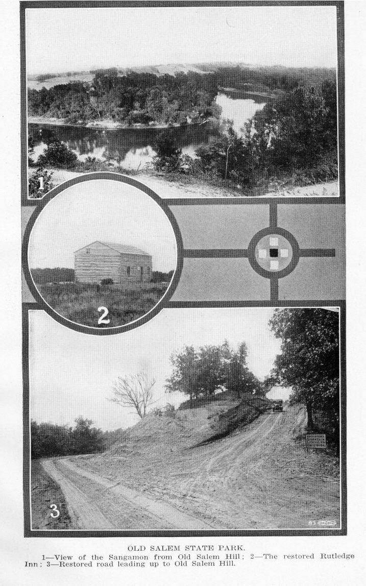
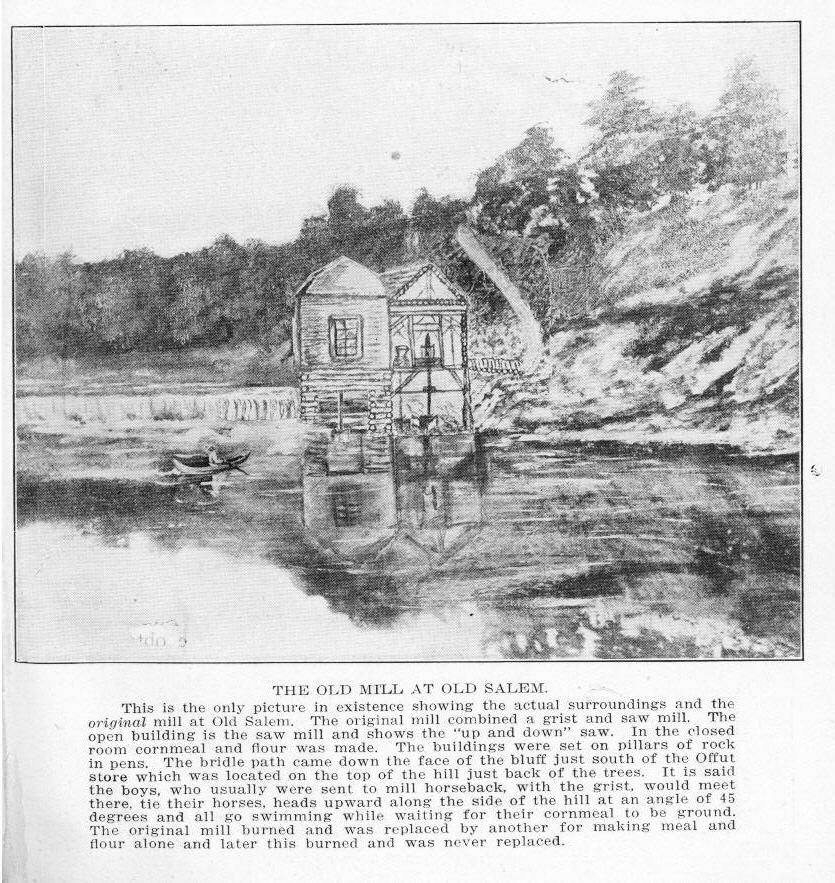
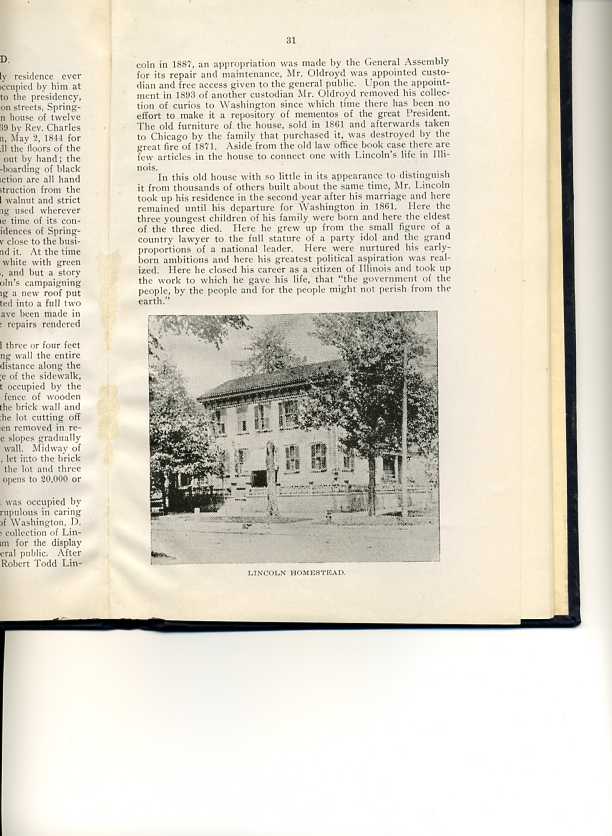
The Lincoln Homestead, the only residence ever owned by Abraham Lincoln, and the one occupied by him at the time of his nomination and election to the presidency, situated at the northeast corner Eighth and Jackson streets, Springfield, is a plain, old fashioned two story, wooden house of twelve rooms, fronting west on Eighth street, built in 1839 by Rev. Charles Dresser, and purchased from him by Mr. Lincoln, May 2, 1844 for a consideration of $1,500. The frame work and all the floors of the old house are of oak; the laths of hickory, split out by hand; the doors, door frames, window frames and weather-boarding of black walnut. The nails, sparingly used in its construction are all hand made. The most noticeable features of its construction from the builder's point of view is the prodigal use of solid walnut and strict economy in the use of iron-wooden pegs being used wherever practicable in lieu of the customary nail. At the time of its construction it was one of the more pretentious residences of Springfield, located on the outskirts of the town, but now close to the business center of the city, which has grown up around it. At the time of its purchase by Mr. Lincoln it was painted white with green window shutters, after the fashion of the times, and but a story and a half in height. During one of Mr. Lincoln's campaigning tours in the "Forties", Mrs. Lincoln, while having a new roof put on the residence, took occasion to have it converted into a full two story house as it appears today. No changes have been made in the house since Mr. Lincoln left it, except the repairs rendered necessary by decay of the original material. The lot on which the house stands is elevated three or four feet above the grade of the street and a brick retaining wall the entire length of the west end and about one-fourth the distance along the south side, built up vertically from the inner edge of the sidewalk, holds the earth in place on that part of the lot occupied by the house. Surmounting this wall there is a low fence of wooden pickets. The high board fence connecting with the brick wall and continuing along the south side to the rear of the lot cutting off the view of the back yard from the street, has been removed in recent years and the sodded lawn back of the house slopes gradually to the sidewalk without any intervening fence or wall. Midway of the west end of the lot a flight of five stone steps, let into the brick wall, leads up from the sidewalk to the level of the lot and three more such steps to the old walnut door which now opens to 20,000 or more visitors every year. After Mr. Lincoln left the house in 1861 it was occupied by various tenants, some of whom were none too scrupulous in caring for the premises. In 1883 O. H. Oldroyd, now of Washington, D. C., rented the house and installed in it his private collection of Lincoln mementos and made of the house a museum for the display of his large and interesting collection to the general public. After the conveyance of the property to the State by Robert Todd Lincoln in 1887, an appropriation was made by the General Assembly for its repair and maintenance, Mr. Oldroyd was appointed custodian and free access given to the general public. Upon the appointment in 1893 of another custodian Mr. Oldroyd removed his collection of curios to Washington since which time there has been no effort to make it a repository of mementos of the great President. The old furniture of the house, sold in 1861 and afterwards taken to Chicago by the family that purchased it, was destroyed by the great fire of 1871. Aside from the old law office book case there are few articles in the house to connect one with Lincoln's life in Illinois.
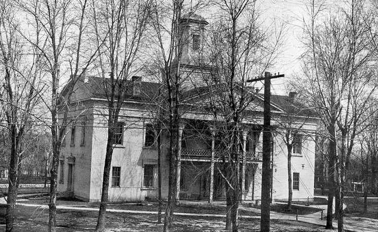
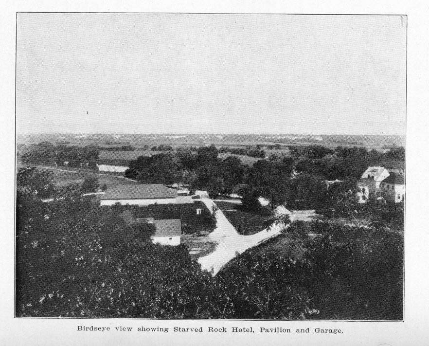
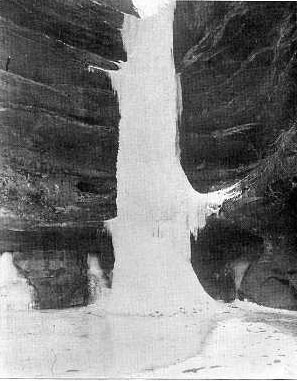
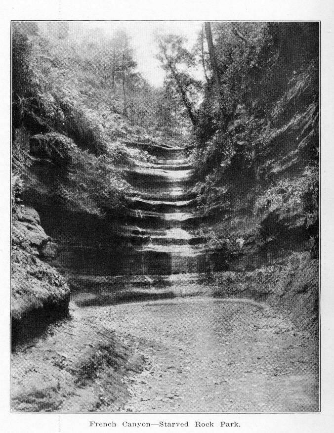
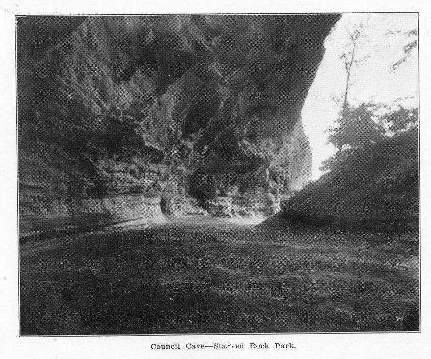
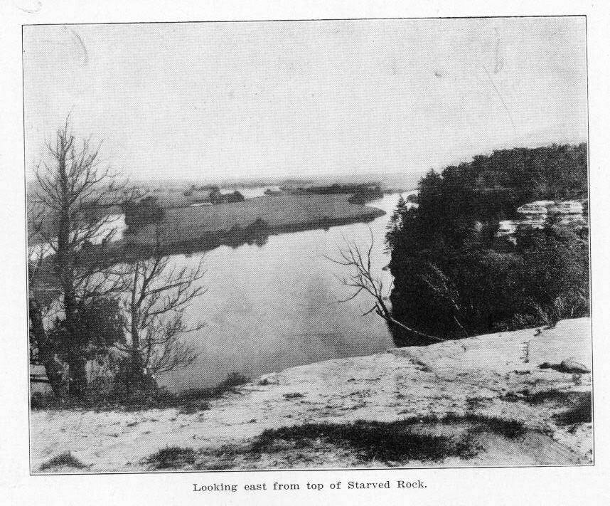
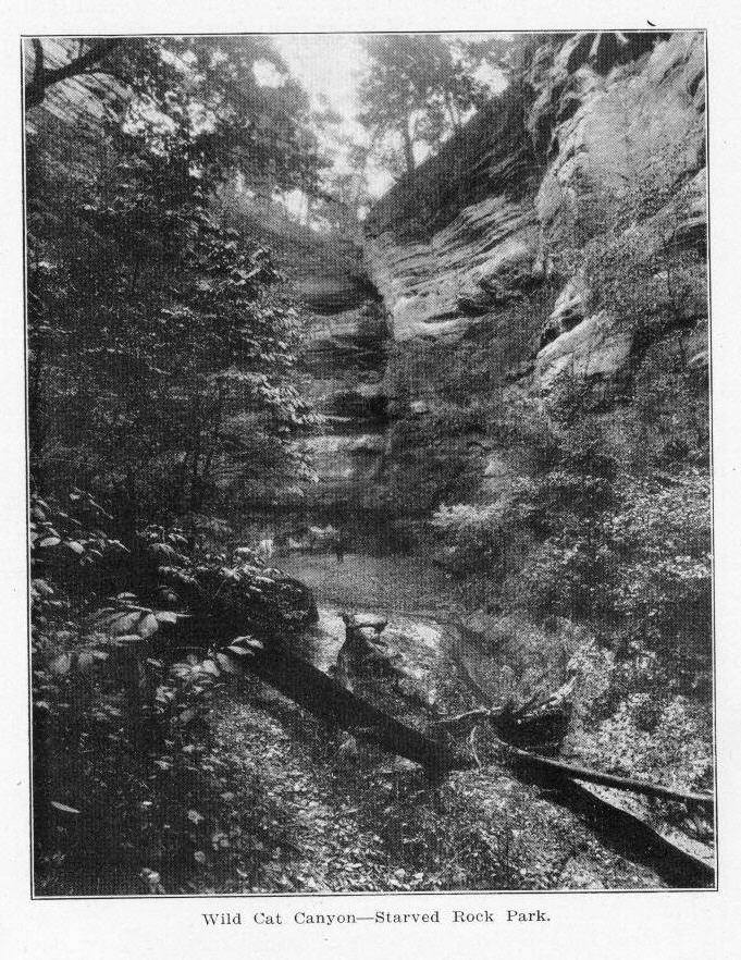
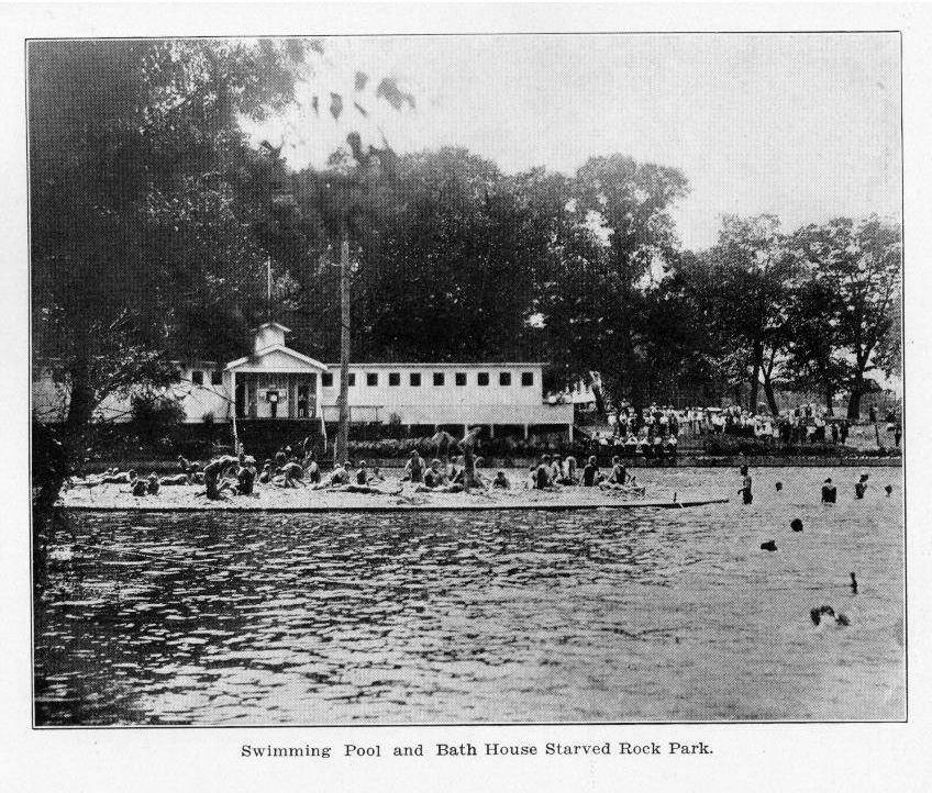
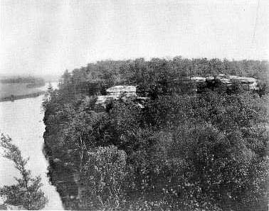
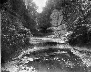
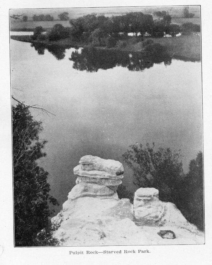
In this old house with so little in its appearance to distinguish it from thousands of others built about the same time, Mr. Lincoln took up his residence in the second year after his marriage and here remained until his departure for Washington in 1861. Here the three youngest children of his family were born and here the eldest of the three died. Here he grew up from the small figure of a country lawyer to the full stature of a party idol and the grand proportions of a national leader. Here were nurtured his early-born ambitions and here his greatest political aspiration was realized. Here he closed his career as a citizen of Illinois and took up the work to which he gave his life, that "the government of the people, by the people and for the people might not perish from the earth." French Canyon Council Cave East View Wild Cat Canyon Starved Rock Park, the scene of the last stand of the Illinois Indians, the site of Fort St. Louis, established by LaSalle, the site of the First Mission in Illinois established by Father Marquette, the mecca of Romance and Indian Legendry, the most beautiful spot between the Allegheny and the Rocky Mountains, is a tract of some nine hundred acres of rough, wooded bluffland, mostly covered with timber and lying along the south bank of the Illinois River, midway between Ottawa and La Salle. It has three road entrances; the western at the highway bridge crossing the Illinois river, one mile south of the village of Utica; the eastern at the Salt Well, six miles west of Ottawa, and the southern, one mile directly south of the rock. The entrance for river and interurban traffic is on the river bank at the base of Starved Rock. November 29, 1911, the State of Illinois, purchased from Ferdinand Walther, 280 acres of land at a price of $146,000.00. Since then by purchase the area of the park has been increased to approximately nine hundred acres. The value of the property with improvements is $350,000.00. In the height of his glory, LaSalle, standing among the wooden ramparts of Fort St. Louis, looked down upon a concourse of wild human life, lodges of bark and cabins of logs, clustered in the open places or along the edge of the bording forest; a mile and a half to the west the lodges of the Illinois, sheltering 6,000 souls and scattered along the valley the cantonments of numerous other tribes, making a total of 20,000 people gathered in the neighborhood. Today from the same spot, preserved as a public park and pleasure ground for the people of the State of Illinois, the visitor, facing the east, gazes down upon a glorious panoramic view of the wonderfully fertile and beautiful valley of the Illinois, dotted here and there with fields of growing grain and showing evidences of thrifty husbandry. To the west, instead of the laboring squaw, the warriors lounging in the sun and the whoop and shouts of the native Indian children gamboling on the grass, may now be seen a modern hotel, its broad verandas filled with guests and tourists; a bathing pool and dancing pavillion from which may be heard the clamor and laughter of the modern pleasure seekers; and a children's playground equipped with modern play apparatus. The entire park is equipped with an electric light, sewage, and artesian water system, and a fire fighting apparatus. Low portions are drained so as to safeguard health. HISTORY. During the summer of 1673 Father Marquette and Louis Joliet, accompanied by five men, set out in two birch bark canoes from St. Ignace, under commission from Frontenac, French governor of Canada, to discover and explore the Mississippi. Four years earlier Father Marquette had met some Illinois Indians at his mission at the west end of Lake Superior. They had gone there to trade and invited the priest to come to their village. The message from Frontenac, therefore, was received with pleasure by Marquette, for it promised him the opportunity to carry out his wish to go among these Indians. Advancing by the way of the Fox and the Wisconsin Rivers, they reached the Mississippi on June 17, the first Frenchman to behold that river. Having gone as far as the mouth of the Arkansas, they turned and following the advice of some Indians, that the route would bring them most quickly to the Lac de Illinois (Lake Michigan), began the ascent of the Illinois River. In the plain directly across and below the Rock of St. Louis, now Starved Rock, they came to Kaskaskia, then an Illinois Indian town of seventy-four cabins. Two years later Marquette returned to these Indians and established a mission, the first within the area of our State. He remained only a short time, and on account of continued illness, was forced to leave, his death occurring while on his way to St. Ignace. In 1682, LaSalle, accompanied by Tonti and over one hundred French and Indians, returned from their triumphal journey, in which tney had descended the Illinois to the mouth of the Mississippi, and had taken possession of the valley in the name of the king of France. During the autumn of that year they came from Mackinac to this spot on the Illinois, where work was begun on a palisaded fort, at the top of the cliff, called Fort St. Louis. Two years before LaSalle had visited the Illinois town, then deserted, and had ordered Tonti to examine the rock and make it his stronghold in case of necessity. This constituted an ideal site for defense, for it was approachable from only one side and might easily be made an impregnable fortress for a few men against hundreds. According to the plan of LaSalle this was the beginning of what promised to be the first permanent colony in Illinois. He hoped to make it the great center for the western fur trade. It was his design also to take control of the mouth of the Mississippi by building another fort, and thus secure an outlet for the trade of the Illinois colony, as well as that of the entire valley. His imagination built up an empire in the valley which would lead to the dominance of French power in the New World, and he began to make grants of land to his followers according to the feudal law of the time. During the winter, negotiations were carried on with the Indians gathered in the valley and nearby canyons. There were in the vicinity, besides the six thousand Illinois, Shawnee, Miami and numerous other tribes numbering an additional ten thousand or more. The scene presented to LaSalle from this watch tower found a worthy word painter in Parkman, who wrote: "The broad, flat valley of the Illinois was spread beneath him like a map, bounded in the distance by its low wall of woody hills. The river wound at his feet in devious channels among islands bordered with lofty trees; then far on the left, flowed calmly westward through the vast meadows, till its glittering blue ribbon was lost in hazy distance. LaSalle looked down from his rock on a concourse of wild human life. Lodges of bark and rushes, or cabins of logs, were clustered on the open plain or along the edges of the bordering forests. Squaws labored, warriors lounged in the sun, children whooped and gamboled on the grass. Beyond the river, a mile and a half on the left, the banks were studded once more with the lodges of the Illinois. LaSalle was able to make his own terms, for these Indians had already struggled unsuccessfully against the Iroquois, terrible enemy of the western tribes. They looked upon the French as allies who would be able to foil an attack by the warriors of that powerful confederacy, which, at the time, seemed imminent. The Iroquois failed to appear and the summer passed peacefully away. But to LaSalle they were months of gloom, for his staunch friend and supporter, Count Frontenac, had been recalled. In his stead reigned LaBarre, as governor of the French possessions in America. His jealous disposition soon led him to accuse LaSalle of attempting to build up a kingdom in the heart of the New World. His enmity extended so far that he learned with satisfaction of the advance of the Iroquois, and signified to their representative his desire to have LaSalle put to death. By his order supplies were cut off from the little company of Frenchmen at Fort St. Louis; LaSalle's property in upper Canada was seized; and his influence with the king was assailed. Determined to regain his position, LaSalle set out for Quebec, meeting on the way thither a representative of the governor, who was sent to take possession of the new fort. LaSalle soon sailed for France, where he gained permission to appear in the presence of the great monarch, Louis XIV, and made his plea. His plan to build a fort on the Gulf of Mexico, which would be a menace to the Spanish possessions, and another fort sixty leagues above the mouth of the River Colbert, or Mississippi, which would constitute a stronghold against the advance of the English, met with instant favor. An officer was dispatched to LaBarre with the royal command that he should restore all of LaSalle's possessions. LaSalle, himself, was appointed leader of the expedition to be sent to the Gulf of Mexico, and finally succeeded, after overcoming many difficulties, in setting out with four hundred men on board four vessels. Failure seemed to shadow the expedition from the start, for scarcely had they sailed from Rochelle (July 24, 1684) when trouble arose between LaSalle and Captain Beaujeu, who had charge of the chief vessel. One ship was captured by Spaniards, and January, 1685, another went aground on the coast of Texas and was lost. LaSalle and his followers went ashore and built a fort (Fort St. Louis). Beaujeu soon deserted in one of the remaining vessels, and the other was wrecked. Thus the little colony, with all means of return to France cut off, and surrounded by hostile Indians, was in a desperate condition. All attempts to find the mouth of the Mississippi failing, LaSalle, with seventeen half starved men, set out on horseback with the hope of reaching Canada, and thus securing succor for the garrison of twenty left in the fort. Reaching the bank of the Trinity River, LaSalle was killed by one of his followers. In the meantime an attempt was made by the Iroquois on March, 1683, to capture Fort St. Louis from the Illinois, but after an unsuccessful siege of six days they withdrew. In 1684 Tonti was placed in full command of the fort. During the month of September, three years later, a party of seven Frenchmen, LaSalle's companions from the gulf colony, saw with great relief after their toilsome journey, the cliff, surmounted by the fort, rising before them. The garrison received them with a salute of musketry. Ascending the circuitous path at the rear of the rock, they found on reaching the top that it was encircled for defense by a palisade and by a number of dwellings, a storehouse and a chapel. A number of Indian lodges were within this area. In the spring, they set out for Canada without giving any information to Tonti and his associates of the death of LaSalle. An account of the journey was given by Joutel, one of the company, who has also given a faithful description of the fort and surroundings when they visited it. "Fort Louis," he writes, "is in the country of the Illinois, and seated on a steep rock, about two hundred feet high, the river running at the bottom of it. It is only fortified with stakes and palisades and some houses advancing to the edge of the rock. It has a very spacious esplanade, or place of arms. The place is naturally strong, and might be made so by art, with little expense. Several of the natives live in it, in their huts. I cannot give an account of the latitude it stands in, for want of proper instruments to take an observation, but nothing can be pleasanter; and it may be truly affirmed that the country of the Illinois enjoys all that can make it accomplished, not only as to ornament, but also for its plentiful production of all things requisite for the support of human life. "The plain, which is watered by the river, is beautified by two small hills, about half a league distant from the fort, and those hills are covered with groves of oaks, walnut trees and other sorts I have named elsewhere. The fields are full of grass, growing up very high. On the sides of the hills is found a gravelly sort of stone, very fit to make lime for building. There are also many claypits fit for making of earthenware, bricks and tiles and along the river there are coalpits, the coal whereof has been tried and found very good." He described the temperate climate, which was suitable he thought, for the growing of Indian corn; and the production of wild grapes and wild apple and pear trees in great quantities. He found the Illinois Indians naturally fierce, revengeful and untrustworthy. The men were occupied in going to war and in hunting, while all labor was performed by the squaws. During September, 1688, Tonti learned from some Arkansas Indians of the death of his friend and leader, and determined to go to the rescue of the forsaken colony on the coast of Texas. It was his aim also to advance with a war party to the Rio Grande and secure that territory, since war had again been declared between France and Spain. With four other Frenchmen and three Indians, they left the fort in October in a pirogue. Before reaching the Red River, early in April, he had been deserted by all save two of his companions. They still pushed on for a time, but were compelled to retrace their steps. It was a toilsome journey during the hot July and August days. Because of the inundated plains, due to the heavy rains, they were forced to abandon the horses, which they had gotten from the Indians. "We crossed," said Tonti, "fifty leagues of flooded country. The water where it was least deep, reached half-way up the legs; and in all this tract we found only one little island of dry land. We were obliged to sleep on the trunks of two great trees placed together, and to make our fire on the trees, to eat our dogs, and to carry our baggage across large tracts covered with reeds. In short, I never suffered so much in my life as in this journey to the Mississippi, which we reached on the 11th of July." In September they arrived at Fort St. Louis. For twelve years Tonti remained at this post carrying on a trade in furs. All outposts on the great lakes and all other advanced posts were ordered abandoned by the King in 1698. Even with this seeming advantage, because of governmental restrictions, the trade at Fort St. Louis decreased. Owing to Indian raids, the route by the Fox and Wisconsin rivers gained precedence over that of the Illinois. A royal order of the year 1702 declared that Fort St. Louis was to be abandoned and that Tonti was to join D'Iberville on the Lower Mississippi. Three years earlier the Illinois, still fearful of the Iroquois, had deserted their village and located at the new Kaskaskia on the Mississippi. Fort St. Louis was reoccupied by French traders for a brief time, but a traveler visiting the spot in 1721 found only ruins. But Starved Rock was the scene of numerous conflicts between the tribes during the succeeding half century. In 1722, we are told, the Peoria, pursued by the Foxes, took refuge on this stronghold. In the siege which followed, the Foxes lost so many of their warriors that they withdrew. None of these encounters is so full of dramatic interest as the one in which tradition has originated the name Starved Rock. Even if the evidence must be regarded as doubtful, the story may well be retold, for through it the name will survive. In 1769, the story goes, Pontiac, chief of the Ottawa, while on a visit to Cahokia, was killed by a Kaskaskia Indian. The Ottawa, aided by the Pottawatomi, in their efforts to avenge this loss, began a war of extermination against the Illinois. The remnant of this tribe finally sought refuge on the site of Fort St. Louis. Driven to desperation by hunger, they finally strove to cut their way through the ranks of their besiegers. In their enfeebled condition they were an easy prey for the enemy, and all save eleven perished. No tribe ever again bore the name Illinois. GEOLOGIC HISTORY. With the essential facts relative to the geographic features and geologic formations of this region in mind, it is not difficult to sketch the geologic history of this very attractive region. The Lower Magnesium Limestone was deposited in shallow marine waters. It points to a time when the sea, probably from the Gulf region, advanced into the interior of the continent and rested here for a sufficient long period of time to account for the accumulation of shell material, and possibly the precipitation of some lime from those sea-waters to give rise to the 250 feet in thickness of this formation. The fossil forms of the marine animals that lived at that time may be found in this limestone. Following the accumulation of lime there must have been a retreat of the sea, and therefore an exposure of the formation in the sea bottom to erosion, for the St. Peters sandstone rests on an eroded surface of the Lower Magnesium limestone within this region. The presence of the sandstone suggests the re-advance of the sea, and a long period of deposition of sands, which must have been brought in to this sea by rivers from neighboring lands. Following the deposition of this St. Peters sandstone, there was another shifting of the shore line of this ancient interior sea, for the Trenton limestone rests on an uneven and eroded surface of St. Peters. These unconformable relationships below and above the St. Peters sandstone indicate partial withdrawal of the sea from the interior of the continent. Such movements of the sea waters were presumably due to movements in the crustal portion of the earth much more widespread than the area under consideration. After the Trenton Limestone, and possible other formations, had accumulated, there was an uplift and deformation of this region. The rock strata, which had been deposited one upon the other with slight interruptions, rested in a nearly horizontal position, but the conditions just west of Utica and in the valley of Vermilion River indicate that before the Coal Measures had been deposited this portion of the State had been arched so that the strata dipped westward at an angle of 25 degrees and declined from the crest of the fold eastward at an angle so low that it is not noticeable to the eye, but may be appreciated by a comparison of elevations above sea level of a given formation over wide areas. Thus, the St. Peters Sandstone may be said to turn from a nearly horizontal position to the east of Vermilion Creek downward and pass quickly below the surface. At Starved Rock, the base of the St. Peter's Sandstone is about 450 feet above the sea level. At the eastern margin of the State of Illinois, the base of that same formation has an approximate position of about 300 feet below sea level. Accompanying the uplift and deformation of the formations, there was a disintegration of the rocks, and a wearing away of the material by streams. A period, undoubtedly many thousands of years in length, elapsed during which the region was exposed as a land area, and was therefore subject to the agents causing rock decay and to the work of streams. Following this period of weathering and erosion, there was a readvance of shallow waters, deposition of sands and clays, numerous partial retreats of the water, and the accumulation of vast quantities of vegetable matter in marginal swamps or lagoons, new advances of the sea by which the vegetable matter which had but just accumulated, was buried under silts and sands. The repetition of such processes many times, through many thousands of years, results in the accumulation of the formation which is known as the Coal Measures. As far as the geologic History has yet been determined, the sea retreated from this portion of the State of Illinois at the close of the Coal Measures time and has never returned. Since then, there has, therefore, been a renewal of rock decay and stream erosion. This long period of erosion was interrupted by the advance of a great ice-sheet from the northeast. It is probable that the ice invaded this region more than once, but the material now found within the area of the proposed park appears to be that deposited by a single ice advance, since the ice melted away, the valley of the present Illinois carried away vast floods from the glacier, and in later epochs within the glacial period, when the ice stood near the present outskirts of the city of Chicago, the great valley at the base of Starved Rock received the waters from the melting ice to the northeast, and as that ice retreated, received the waters from Lake Chicago, the ancestor of Lake Michigan. Later the ancient river drained off the waters which covered the area now occupied by Lake Erie, Lake Huron and Lake Superior. Thus, the valley bordering the proposed park has formerly contained waters similar in amount to those that flow over Niagara Falls today. The present river is but a shrunken remnant of the broad river which formerly drained, by this route, to the Mississippi Valley. GEOLOGICAL FORMATIONS. The Lower Magnesium Limestone - This formation is exposed in the valley bottom and at the north bluff of the Illinois River, just below Utica. It does not outcrop within the area of the proposed park, but underlies the park area. Where it is exposed in the vicinity of Utica, it is being used in the manufacture of natural cement. St. Peter's Sandstone - This formation is the one best exposed within the area of the proposed park. It forms the bluffs of the Illinois valley for several miles upstream from a point between Utica and LaSalle. It is the formation which constitutes the bluffs, within the park. Starved Rock, the Devil's Nose, Lover's Leap rock, are all composed of this St. Peter's sandstone, and the walls of the canyons are excellent exposures of this rock. The Trenton Limestone - This formation is not exposed within the area of the proposed park, but may be seen about two miles west of the western end of the park along the banks of the Vermilion River. The Coal Measures - A series of shales, sandstones, limestones, and coal seams constitute what is known as the Pennsylvania formation, or, as it is sometimes called, the Coal Measures. Within the area of the proposed park, there is a variable thickness of coal measure shales, which carry with them some coal overlying the St. Peter's sandstone formation. These rocks are exposed on the uplands at various points. The Glacial Drift - Overlying much of the upland surface there is a mantle of heterogeneous material composed, in large part, of clay, but carrying within that clay many stones and boulders. This formation differs from all those which have been thus far described in that it is not stratified. The material is not assorted, the large and small stones are irregularly distributed throughout the clay. Some of the material has evidently come great distances. The Valley Alluvium - The most recent or youngest geologic formation within this region is composed of the sands, gravels, and silts which the Illinois River has distributed over its bottom lands. This formation is so recent that it may be considered modern. It is, in fact, still in the process of accumulating, for with each overflow of the river some slight addition is made to the amount of alluvium on the bottom lands. BIRD LIFE. By FRANK M. WOODRUFF, Curator, Lincoln Park, Chicago. In the Park, the birds have received much needed protection, and have increased to such an extent that the Ornithologist can find more varieties of birds nesting on and about Starved Rock than any area of the same extent in northern Illinois. This statement can be verified by the classes of students which have visited the Rock during the past year or two. Four members of a class which I brought to Starved Rock two years ago from Saturday noon to Sunday night recorded fifty-eight (58) varieties of resident birds. The more common birds, such as the house wren, cat bird, robin, and wood thrush fairly swarm on the grounds in the early mornings, while the peculiarly rugged inaccessible walls of the canyons afford safe nesting places for the solitude-loving species. At the Deer Park canyon we find the rough-wing swallow nesting in the crevasses of the rock on one side of the high cliff and on the other side, where the rock is replaced by a deposit of soil, may be found a colony of bank swallows. Fastened to the rock known as Lover's Leap, just above the first prominent ledge overhanging the river, may be found the curious bottle-shaped nests of the cliff swallow. These nests are made of hundreds of small pellets of clay which are thoroughly masticated by the bird, the sticky saliva forming a wonderfully hard cement house. After the young swallows have left the nest the English sparrow takes possession, but the young sparrows are so much larger and heavier that the nest crumlbes from the rock and the birds are drowned in the river. Starved Rock is about the northern nesting range of the turkey vulture, and these majestic birds can be seen every day circling about the rock, particularly over Horseshoe and Curtis canyons. A very few miles from Starved Rock are the great swamps at Henry, Illinois, and the Kankakee River, the breeding places of many ducks, heron, and the bald eagle. One is apt to see a stray massive form, the eastern end of which is known as Eagle Cliff. A short distance above Eagle Cliff, a smaller but similar formation is known as the Bee Hive and still further east a spur of the bluff, shaped by the action of the elements into the semblance of a pulpit is known as Pulpit Rock. At the eastern entrance to the Park is the Salt Well, a natural spring of water highly impregnated with minerals. By acquiring this site, the State of Illinois has fittingly returned its most historic landmark, situated amidst scenery of rare excellence, to its citizens for their free and perpetual enjoyment. |
For corrections or additions, please contact me: Sandy Bauer